

Strange Summer Nor’Easter Drops 3 Inches of Rain in 45 Minutes Over Parts of D.C. Area
28
July, 2017
Climate
change related hydrological events. Rain bombs. These are somewhat
uncomfortable subjects. But it’s a basic fact that if you warm the
Earth, you also crank up rates of evaporation and precipitation. And
since we’ve warmed the Earth by about 1.2 C above preindustrial
levels by burning fossil fuels and dumping so much carbon into the
atmosphere, we’ve loaded the climate dice for producing both more
extreme rainfall and more extreme drought events.
Periods of heavy rain this PM into Sat. Swath of 4" likely across MD; 5+" possible DC/Baltimore metro. Flooding concerns center on tonight.

In
the mid-Atlantic today, a strange summer Nor’easter is dropping
multiple inches of rain over parts of Maryland, Virginia and Delaware
in very short time periods. In an area just northwest of Silver
Spring, M.D., an
amazing 3.19 inches of rain fell in just 45 minutes.
A
resident of Gaithersburg, M.D., I experienced a comparable deluge
situation in which my hilltop residence and home office saw a river
forming in its back yard. Just about an hour before, my phone was
sending me warnings to avoid the valley regions. Considering the
flooding we saw in the hills, it’s tough to imagine what the
low-lands might have looked like.
(Extreme
rainfall creates streams through the hilltop residences of
Gaithersburg, MD on July 28 as a strange summer Nor’Easter taps
very high atmospheric moisture levels over the region to produce 1-4
inch per hour rainfall rates.)
It’s
worth noting that 1 inch per hour rainfall rates are considered to be
extreme. But the short-period volumes of rain being produced by this
system (1-4 inch per hour rates) are pretty much off the charts. It’s
coming from a storm that has been fueled by an upper level trough
dipping down over Canada. One that pushed a large frontal system over
the Great Lakes region on Wednesday night. This front then moved
across the Ohio Valley on Thursday and out over the Atlantic by
Friday. Packed with cooler temperatures, the front ran over ocean
waters that are ranging between 1 to 4 degrees Celsius above average.
The extra ocean heat helped to create a very moisture-rich
environment. A coastal low subsequently forming in this very wet
column of air began cranking that moisture over the mid-Atlantic even
as its associated instability produced some extraordinarily powerful
rainstorms.
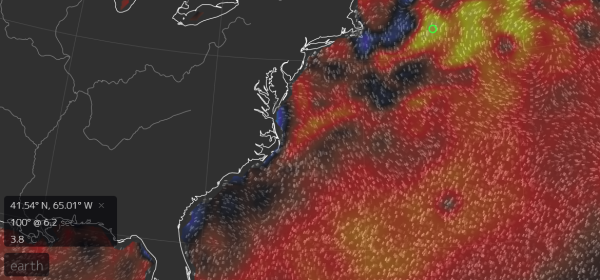
(Sea
surface temperature anomaly map shows a hot blob of ocean water
temperatures off the U.S. East Coast in the range of 1-4 C above
average. A deep-digging trough has enabled a strong coastal low to
form and feed on the amazing amount of moisture bleeding off this
warm water to produce an odd summer nor’easter and related extreme
rainfall over the U.S. East Coast. A number of the factors enabling
the strength of this system are aspects of human-forced climate
change. Notably — the deep summer trough and the very warm Atlantic
Ocean surface waters. Image source: Earth
Nullschool.)
Meanwhile,
the Gulf of Mexico’s warmer than normal waters have throughout the
spring and summer produced tropical levels of moisture over southern
and central sections of the Eastern U.S. — fueling numerous extreme
rainfall events and adding even more punch to this particular event.
Already
warm summer waters produce a serious amount of water vapor. But punch
up ocean temperatures to the above average ranges we see today and
you get even more moisture bleeding out. If an odd, deep, cool summer
trough runs through it, then it provides a big kick of atmospheric
instability in a region where there’s already an abnormal amount of
fuel for storms. Both
the ability of troughs to dig deeper over the U.S. East Coast and
the added ocean heat and moisture are arguably aspects related to
human-caused climate change. So to talk about this particular event
without adding that context would not really be looking at the whole
weather and climate picture.
(UPDATES
TO FOLLOW AS NEEDED)
Links:
Hat
tip to Greg
No comments:
Post a Comment
Note: only a member of this blog may post a comment.