

Pockmark
fields off Helgoland
Researchers
discover methane vents in the German Bight

11
July, 2017
Within
a period of a few months thousands of craters formed on the sea bed
off the North Sea island of Helgoland. Gas escaping out of the sea
floor entrained sand and upon settling created mounds. For the first
time evidence for massive methane release has been discovered in the
area of Helgoland Reef. Knut Krämer of MARUM – Center for Marine
Environmental Sciences at the University of Bremen and colleagues
have published their findings in the journal Scientific Reports.
“We
were surprised to suddenly find a crater landscape in an area that
used to be a flat expanse of sand”, says Knut Krämer, first author
of the article and PhD student at MARUM – Center for Marine
Environmental Sciences at the University of Bremen. Based on detailed
surveys, the study describes a dramatic transformation in the
Helgoland Reef region about 45 kilometers northwest of Helgoland.
Until July 2015, this area was characterized by an almost flat and
featureless sea floor. More recent mapping in November 2015 revealed
a bottom strewn with depressions the size of tennis courts.
Subsequent cruises with the research vessel Heincke in August and
September 2016 confirmed that these craters covered an area of around
915 square kilometers, more than twice the area of the State of
Bremen. Each square kilometer can contain up to 1,200 craters. Based
on the associated high concentrations of methane in the sediments,
the craters were identified as pockmarks.
Bacteria
generate methane
The
term pockmark is used to designate characteristic craters on sea beds
that are formed by the release of liquids or gases from the
sub-seafloor. They can be found worldwide in different types of water
bodies, including lakes, rivers, estuaries, and in coastal to deep
ocean waters. In clay-rich sediments and under low current and wave
conditions, they can sometimes persist over centuries and remain as
evidence of past gas releases.
In
shallow coastal waters with sandy bottoms, under the forcing of tidal
currents and waves, the craters are quickly erased, and therefore
have been rarely observed before. Prior to the postglacial sea level
rise, however, the near-coastal regions in particular were often
wetlands and thus rich in organic material.
Methane is commonly
produced by the bacterial breakdown of this material. The gas can
then accumulate underneath impermeable layers below the sea floor.
Methane released into the atmosphere acts as a greenhouse gas
approximately 25 times more effective than carbon dioxide (CO2).
Measurements
by the research team have shown that around 6.9 million cubic meters
of sediment were displaced as a result of the methane ejection –
sand that would fill 200,000 standard shipping containers. “The
total amount of methane released is difficult to estimate. We do not
know exactly how the gas was distributed in the substrate prior to
the release,” explains Knut Krämer. “But even a conservative
estimate suggests an amount of around 5,000 metric tons. This would
be equivalent to about two-thirds of the previously assumed annual
emission of the entire North Sea.”
The
sea floor is altered by currents and waves
Krämer
and his co-authors presume that the trigger for the pockmark
ejections was a series of storms with waves up to seven meters high
and periods of around ten seconds that caused large pressure
fluctuations in the sea bed. These acted like a pump on the gas
stored there. The sea floor eventually yielded to the gas pressure
and the gas escaped into the water column, dragging sediment with it.
This was then redeposited on the lee side of the current or wave,
producing a characteristic pattern of craters and mounds.
“This
study is an excellent example of cooperation among various institutes
that are involved in coastal research,” says PD Dr. Christian
Winter, chief scientist of the survey expedition and leader of the
Coastal Dynamics working group at MARUM. “We obtain measurements
together on the German research ships and combine the expertise of
different disciplines.”
The
Helgoland Reef pockmarks are the first to be observed of this form in
the German Bight. Knut Krämer surmises that “the frequency of
triggering storm waves suggests that this could be a recurring
phenomenon that has been previously overlooked”. Detection of the
relatively shallow craters has only become possible through recent
advances in the development of highly accurate multibeam
echosounders. It is also assumed that the craters, located in mobile,
sandy sediments, will quickly be leveled again by waves and currents
as soon as no more methane is being released.
Compared
to methane emissions caused by humans, the amount from the pockmark
field discovered here is small. It is equal to only 0.5 per cent of
the annual anthropogenic methane emissions by Germany. It is
believed, however, that coastal regions worldwide with rich methane
occurrences are in a similar state of instability. It is therefore
possible that highly dynamic coastal regions have been overlooked as
an important contributor to the global methane budget, says Knut
Krämer. “We hope that our article will help to stimulate
scientific discussion and further investigations of these kinds of
methane sources.”
Contact:
Knut
Krämer
Telephone:
0421-21865582
Email:
kkraemer@marum.de
Original
publication:
Knut
Krämer, Peter Holler, Gabriel Herbst, Alexander Bratek, Soeren
Ahmerkamp, Andreas Neumann, Alexander Bartholomä, Justus E.E. van
Beusekom, Moritz Holtappels und Christian Winter: Abrupt emergence of
a large pockmark field in the German Bight, southeastern North Sea.
Scientific Reports 7, 2017; DOI: 10.1038/s41598-017-05536-1
Further
information/photo material:
Ulrike
Prange
MARUM
Public Relations
Telephone:
0421 218 65540
Email:
medien@marum.de
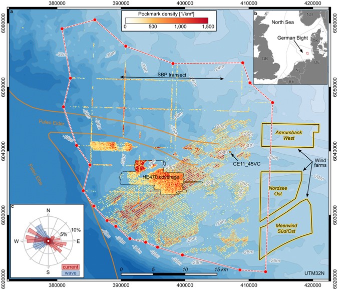
The Helgoland Reef pockmark field. (a) Extent of the field and pockmark density in relation to the course of the Paleo Eider and Paleo Elbe valley29. The location of the sub-bottom profiler (SBP) transect and location of core CE11_45VC from Fig. 4 are indicated. (b) Location of the Helgoland Reef pockmark field in the North Sea. (c) Histogram of the hydrodynamic climate at Helgoland Reef. The data were provided by the COSYNA system34operated by Helmholtz-Zentrum Geesthacht Zentrum für Material- und Küstenforschung GmbH. The maps in this figure were generated using QGIS Version 2.14.1143. Bathymetry data was made available by the GPDN project44. Maritime boundaries and wind farm polygons were made available by the EMODnet Human Activities project45, funded by the European Commission Directorate General for Maritime Affairs and Fisheries. Wind farm data were collected by the OSPAR Commission. Maritime boundaries were provided by the European Environment Agency. Land polygons ©OpenStreetMap contributors46 (available under the Open Database License; see www.openstreetmap.org/copyright).
ABSTRACT
A
series of multibeam bathymetry surveys revealed the emergence of a
large pockmark field in the southeastern North Sea. Covering an area
of around 915 km2, up to 1,200 pockmarks per square kilometer have
been identified. The time of emergence can be confined to 3 months in
autumn 2015, suggesting a very dynamic genesis. The gas source and
the trigger for the simultaneous outbreak remain speculative.
Subseafloor structures and high methane concentrations of up to
30 μmol/l in sediment pore water samples suggest a source of
shallow biogenic methane from the decomposition of postglacial
deposits in a paleo river valley. Storm waves are suggested as the
final trigger for the eruption of the gas. Due to the shallow water
depths and energetic conditions at the presumed time of eruption, a
large fraction of the released gas must have been emitted to the
atmosphere. Conservative estimates amount to 5 kt of methane,
equivalent to 67% of the annual release from the entire North Sea.
These observations most probably describe a reoccurring phenomenon in
shallow shelf seas, which may have been overlooked before because of
the transient nature of shallow water bedforms and technology
limitations of high resolution bathymetric mapping.
No comments:
Post a Comment
Note: only a member of this blog may post a comment.