

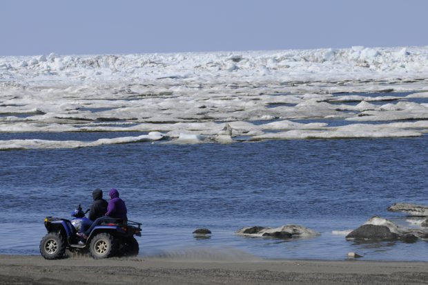

Record temperatures in Alaska - about 27 - 30 degrees Centigrade!

Huge temperature anomalies in the Arctic and North Pole

Pampa, Texas, the plains. For reference, those pumps are 7 feet. tall.

God must be real angry over them gays - lol
Evacuations underway

Flooding
from record-setting rains in Texas and Oklahoma swept away hundreds
of homes and left at least three people dead.
"We
do have whole streets that have maybe one or two houses left on them,
and the rest are just slabs," said Kharley Smith, emergency
management coordinator in Hays County, Texas.
Crews
are still surveying damage, she told reporters Sunday; between 350
and 400 homes in the Texas county are gone, and more than 1,000 were
damaged. Two main bridges washed away, she said, and others sustained
major structural damage.
An analysis from Wunderblog
Summer Weather Watch: Keep an Eye on These Five Possibilities
By Bob Henson
22
May, 2015
It’s
Memorial Day weekend, the traditional start of the U.S. summer
season, and millions are wondering what kind of weather the next
three months will bring. Seasonal predictions have their limits any
time of year, and that’s especially true in summer, when
upper-level winds are weaker and local influences play a larger role.
Moreover, the largest single influence on year-to-year climate
variability--the El Niño/Southern Oscillation (ENSO)--is often at
low ebb in the northern summer.
Not so this year. An unseasonable
El Niño event is
now approaching moderate strength and is projected to continue
intensifying through the summer, perhaps reaching record or
near-record strength for the time of year by August. Instead of the
typical lack of a summertime push from El Niño or La Niña, we’re
thus left with a much different kind of prediction challenge: a
summer setup so unusual that we have few analogs to go by. With that
caveat, I’ll stick my neck out and offer a Top Five List (with
apologies to David Letterman) of things I’ll be watching for as the
lazy, crazy, and occasionally hazy days of summer unfold.
 Figure
1. Departures
from average temperature across the U.S. for the summers of 1982 and
1997, both of which led into strong El Niño events. Image credit:
NOAA/ESRL/PSD.
Figure
1. Departures
from average temperature across the U.S. for the summers of 1982 and
1997, both of which led into strong El Niño events. Image credit:
NOAA/ESRL/PSD.
 Figure
2. The
weather prediction firm WSI is calling for relatively mild conditions
this summer across the bulk of the United States, with unusual heat
confined mainly to the western U.S. and Florida. Image
credit: WSI.Cool,
man, cool
Figure
2. The
weather prediction firm WSI is calling for relatively mild conditions
this summer across the bulk of the United States, with unusual heat
confined mainly to the western U.S. and Florida. Image
credit: WSI.Cool,
man, cool
Figure
1. Departures
from average temperature across the U.S. for the summers of 1982 and
1997, both of which led into strong El Niño events. Image credit:
NOAA/ESRL/PSD.Figure
2. The
weather prediction firm WSI is calling for relatively mild conditions
this summer across the bulk of the United States, with unusual heat
confined mainly to the western U.S. and Florida. Image
credit: WSI.Cool,
man, coolThe summers of 1982 and 1997, which preceded the two strongest El Niño events on record, were cooler than average across most of the United States (see Figure 1 above). No analog is perfect, but based in part on the patterns observed in those two years, “we expect the weakest nationwide cooling demand since at least 2009,” says WSI in its summer energy outlook for 2015 (Figure 2). Other years with at least a moderate Oceanic Niño Index value (at least +1.0) in Jun-Jul-Aug include 1972, 1965, and 1957; all but 1957 had widespread below-average summer temperatures.
Precipitation
signals for the summer are less straightforward, although during
winter El Niño tends to bring wetter-than-average conditions across
the southern half of the United States. The strong subtropical jet
stream that’s fed much of the low-latitude U.S. rainfall over the
last month may weaken as we get into summer, then restrengthen in the
fall, but signals remain positive for widespread summer moisture.
The
average of a variety of climate models assembled through the North
American Multi-Model Ensemble (NMME)
suggests relatively wet conditions across much of the nation, with a
cooler-than-average pocket in the nation’s heartland and relatively
warm temperatures close to the coasts. These tendencies are reflected
in the National Weather Service summer outlook (see Figure 3 below).
The central U.S. already has a head start toward a fairly mild summer
due to the extremely wet conditions across most of the Plains over
the last month. Even when the rains abate and the summer sun kicks
in, some of that energy will go toward evaporating surface-based
moisture, rather than heating up the ground and the surface
air.
 Figure
3. Seasonal
predictions from the National Weather Service (June-August) showing
where the odds are leaning for temperature (left) and precipitation
(right). “EC” denotes equal chances of above- or below-average
conditions. Image credit: NWS/Weather
Prediction Center.For
fire and heat, head northwest
Figure
3. Seasonal
predictions from the National Weather Service (June-August) showing
where the odds are leaning for temperature (left) and precipitation
(right). “EC” denotes equal chances of above- or below-average
conditions. Image credit: NWS/Weather
Prediction Center.For
fire and heat, head northwestLandscapes are parched from most of California up to the interior of Alaska, as well as adjacent northwest Canada. A major high-latitude heat wave sent temperatures on Thursday in Barrow, AK, up to 47°F, the warmest ever observed so early in the season and only the second time that temperature has been reached before June (more here from the Weather Channel’s Jon Erdman).
The warm temperatures have
triggered unprecedented
flooding that’s closed
more than 50 miles of
the Dalton Highway, a key route through northern Alaska. It may be a
particular rough season for wildfires across those higher-elevation
forests where snow was extremely scant this past winter, from the
Sierras north through the Cascades and into British
Columbia.Hurricanes
aplenty in the northeast Pacific

All signs point toward a blockbuster year for tropical cyclone activity in the northeast Pacific basin, a region favored by the proximity to unusually warm sea-surface temperatures (SSTs) associated with El Niño. SSTs are already more than 1°C (1.8°F) above average over a large swath of the region where northeast Pacific hurricanes typically form.
This morning the National Hurricane Center
is investigating
two potential tropical cyclones for
possible development in the northeast Pacific, and models suggest
that one of these could become the the farthest-west tropical cyclone
on record for this basin so early in the year. It’s not out of the
question that at least one northeast Pacific tropical cyclone will
move toward Baja California later this summer, perhaps bringing heavy
rain and wind to the southwest U.S.
In addition, the northwest
Pacific is off to a rip-roaring season, withthree
Category 5 storms to date,
the most ever recorded so early in the year. Conditions should lean
toward more tranquility across the North Atlantic, where El Niño
effects will likely lead to a below-average year for tropical cyclone
activity. NOAA will issue its Atlantic hurricane outlook on
Wednesday, May 27.Figure
4. Unusually
early warmth now across Alaska and western Canada may push into the
Arctic next week, as shown by temperature anomalies predicted by the
0000 GMT Thursday run of the GFS model for 0000 GMT Wednesday, May
27. Image credit: ClimateReanalyzer.com/University
of Maine.Another
crucial year for Arctic sea ice
The extent of sea ice in and near the Arctic is already close to record-low values for this time of year. Now that we’re approaching the summer solstice, a key variable that will shape ice melt is the extent of cloudiness over the next few weeks; clear skies allow the round-the-clock sunlight of the midsummer Arctic to have maximum impact on the ice.
Long-range models
project that the heat wave across northwest Canada and Alaska will
push still further north next week, sending temperatures close to or
above the freezing mark across a large swath of the western Arctic
weeks ahead of schedule.
This could result in widespread formation of
melt ponds atop the ice, which absorb additional heat from the sun
and hasten further melting. It’s too soon to say for sure--the
weather in June and July will play a huge role--but I’d consider a
new record-low extent for Arctic ice a real possibility for
2015.Taking
aim at a new global heat record
This year is already the warmest in global records for the period January through April. El Niño tends to warm Earth’s atmosphere (by suppressing the upwelling of cold water and spreading oceanic heat over a large area, where it can warm the air above). So barring any major volcanic eruptions, we can expect the next three months to keep this year rolling toward a likely, if dubious, victory over 2014 in the troublesome global-heat race.Across the soaked Plains, a memorable Memorial Day weekend
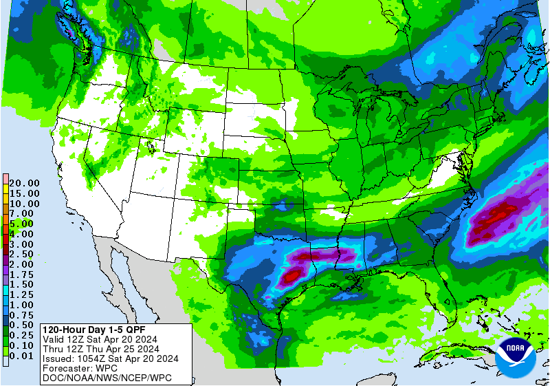
Just when it seemed more water couldn’t possibly fall over Texas and Oklahoma, yet another Pacific storm system will wring out more heavy rains this weekend. Flash flood watches are already posted for much of the two states, plus western Arkansas, with five-day rainfall amounts likely to top 3” over large areas and exceed 6” in spots.
With the rains
juxtaposed over some locations that have received 10” to 20” over
the last several weeks, there’s a high potential for dangerous
flash flooding this weekend, as well as major river flooding in the
days that follow. Severe weather should be relatively subdued this
weekend, with a few tornadic storms possible in scattered pockets as
the upper low now over the Southwest slowly progresses east.
Outside
of the plains, travel
impacts should be relatively minimal,
although showery conditions in many areas will dampen more than a few
outdoor activities. Temperatures will be a bit cooler than average
over much of the West, while an early-season “warm wave” begins
building toward the East Coast.
Have a great holiday weekend, everyone!
Bob Henson
 Figure
5.
A thunderstorm over central Pennsylvania on Sunday, May 17. Image
credit: wunderphotographerbaxtheweatherman.
Figure
5.
A thunderstorm over central Pennsylvania on Sunday, May 17. Image
credit: wunderphotographerbaxtheweatherman.
Have a great holiday weekend, everyone!
Bob Henson
Figure
5.
A thunderstorm over central Pennsylvania on Sunday, May 17. Image
credit: wunderphotographerbaxtheweatherman.
No comments:
Post a Comment
Note: only a member of this blog may post a comment.